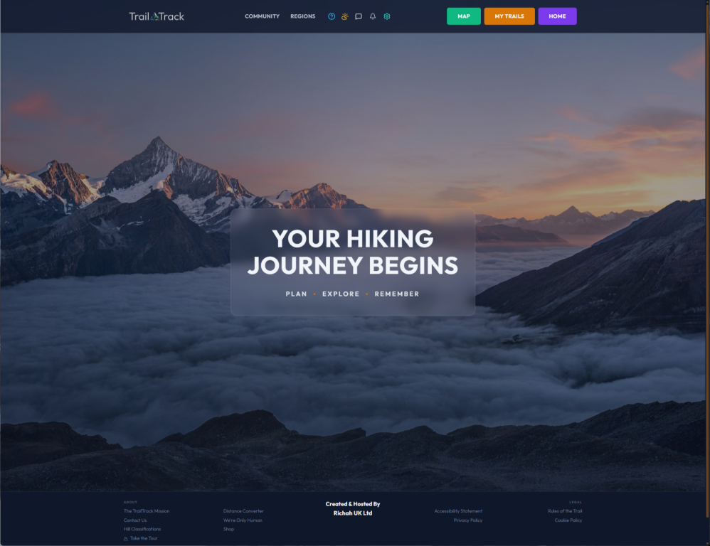
TrailTrack
See how we’re using custom software and OS mapping to build TrailTrack, a better way for the community to plan, track, and record their days on the fells.
TrailTrack: Building a Comprehensive Platform for UK Hill Walkers
We created TrailTrack because, as hill walkers ourselves, we recognized a clear gap in the market for a tool that truly understood our needs.
Living in the Lake District we could see that while there are plenty of fitness apps out there, almost all of them are designed for road runners or cyclists. There wasn't anything that truly "got" the specific needs of a UK hill walker or a fell runner—someone who lives by Ordnance Survey maps, obsesses over logging Wainwrights, and needs a mountain-specific weather forecast before they even think about heading out. We started building TrailTrack because we need it for our own days in the hills, and nothing else on the market quite hit the mark.
Because we are the team and the client, we’ve been able to approach TrailTrack from every angle. We handled the software architecture, the visual design, and the marketing strategy as one unified process. It’s a hugely complex build involving a web platform and a mobile app, but because we use the tool ourselves, we’ve been able to keep it practical and focused on what actually matters when you're halfway up a mountain with wet boots and a phone that’s rapidly losing battery.
Designing a Mapping System for the Real World
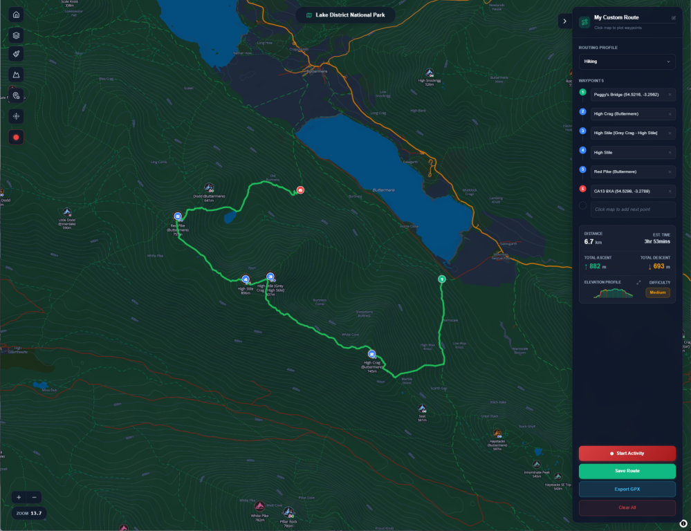
The most important part of any walking app is the map. We decided early on that a one-size-fits-all approach wouldn't work. When you're looking back at a walk you've finished, you want to see the detail of the paths and the terrain clearly. For this, we used Leaflet, an open-source library combined with CyclOSM tiles. We chose these specifically because they render footpaths and contours in a way that's easy to read on a screen.
However, when it comes to planning a new route, walkers in the UK and Ireland have a very specific preference: Ordnance Survey (OS) maps. We integrated the OS Vector Tile API into our route planner to give users that familiar "paper map" feel with the benefits of a digital interface. We are currently refining how the interactive elements of this map work, focusing on making the "snap-to-path" logic feel as natural as possible so that planning a 10-mile day out doesn't feel like a chore.
From a design perspective, we made sure the map doesn't feel cluttered. We used a double-layer effect for route lines—a sharp line on top of a soft glow—so the path stands out against the detailed background of the OS map.
We’ve also added a great little feature that lets you identify each waypoint at a glance. Even better, our planner now tells you whether you'll be walking on a track or a road - a really handy function when plotting your journey. Nothing worse than thinking you're off on a TrailTrack adventure only to find you need to cross the A66 to get there!
We also automated the social side of the map. When a user shares a route on social media, our system uses the Mapbox Static Images API to automatically generate a high-quality image of that specific route. It means the marketing for the platform happens naturally as users share their progress.

Planning for the Next Adventure: Route Creation and GPX Exports
Building a site that just records where you've been isn't enough; we wanted to build a tool that helps you decide where to go next. We’ve spent a lot of time perfecting how users can plot their own paths across the fells, allowing for a mix of following known tracks and drawing freehand for those off-piste scrambles.
Once a route is planned, we made sure it was incredibly easy to get that data off the screen and into the real world. You can download your planned routes as GPX files to load onto a Garmin, a Suunto, or even just back into our own mobile app. By making the export process seamless, we’re ensuring that the software stays useful even when you’re in a "dead zone" with no signal. It’s about creating a bridge between the digital planning phase and the physical hike or run.
Handling GPS Data with Precision
One of the biggest technical hurdles was how we process GPS data. When a walker uploads a file, the data is often "noisy." If you stand still at a summit for five minutes, a GPS sensor might think you’ve moved fifty meters back and forth, which inflates your total distance and ascent.
Instead of relying on guesswork, we built a custom parsing engine that handles .gpx, .tcx, and Garmin’s native .fit formats. To keep the data accurate, we implemented two straightforward rules: a 3-meter elevation threshold to filter out barometric jitter and a 50km/h speed sanity check to discard "GPS jumps" where the signal bounces off a rock face.
We also built in a 3-minute stop-gap filter. If you stop at a summit café or sit down for lunch, the system automatically detects that gap and excludes it from your moving time. This ensures that your "total duration" reflects the actual effort of the walk rather than how long you spent eating a sandwich. We also calculate Grade Adjusted Pace (GAP), which shows you what your equivalent speed would be on level ground—a much more useful metric for fell runners who need to know their true intensity on a steep climb.
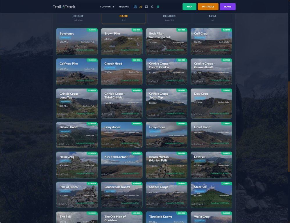
Automatic Hill Logging: Removing the Post-Walk Admin
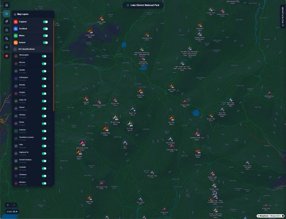
For many walkers in the UK, the goal is reaching the top of specific lists of hills, like the Wainwrights in the Lakes or the Munros in Scotland. We wanted to take the manual work out of this. We built an "Auto-Logging" feature that cross-references a user's uploaded route against our database of thousands of summits.
After a long ten-mile day in the rain, the last thing you want to do is sit down and try to remember exactly which fells you crossed and in what order. Did you go over High Raise, or did you skirt around it? The auto-feature does that heavy lifting for you. To ensure the logging is accurate, the system requires at least three consecutive GPS points to be within 20 meters of the actual summit coordinates. When a match is found, the hill is automatically added to your personal "Summit Log."
This means that when you come to write up your journal later, all the facts are already there. The fells are listed, the heights are recorded, and the timeline is set. It lessens the "work" of being a hill walker and lets you focus on the memories instead of the data entry.
Photos and the Geo-Tagging System
Photos are a huge part of the walking experience, but they can be a nightmare to organize. We built a system that automatically geo-tags photos and pins them to the map. If your photo has GPS data in its EXIF metadata, we place it exactly where it was taken. If it doesn't, we match the photo's timestamp to the nearest point on your GPX track.
To keep the maps clean, we implemented a 500-meter proximity guard. A photo will only be pinned to the route if it was actually taken within 500 meters of the path you walked. This prevents "cloud-synced" photos from a different day or a different location from cluttering up your mountain memories.
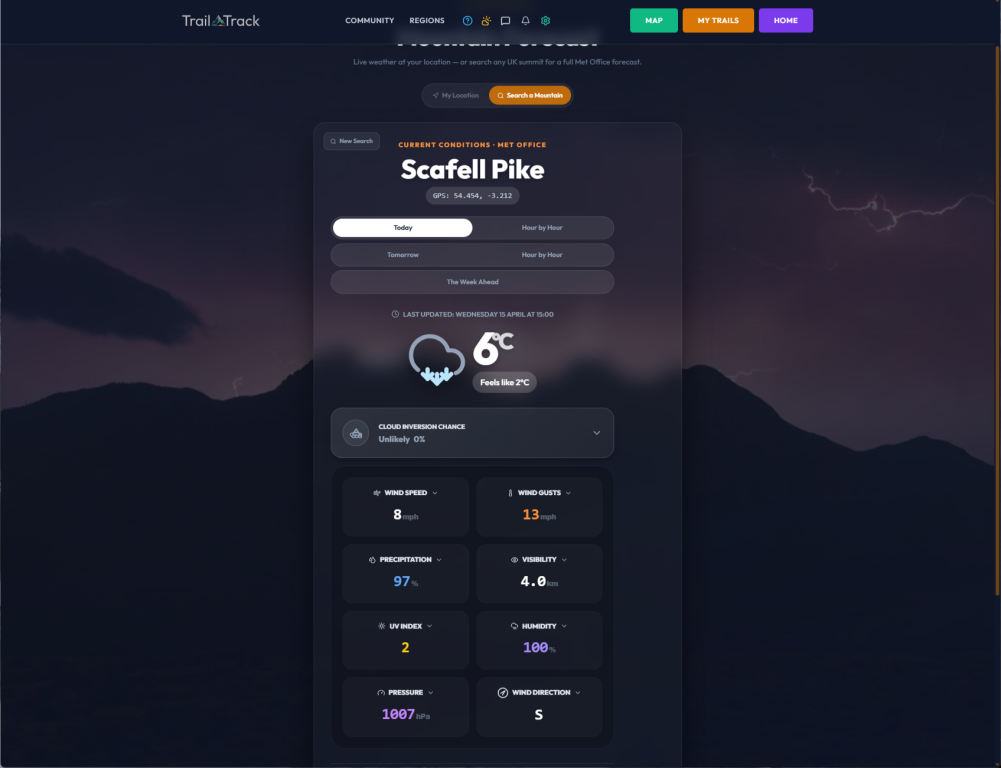
Accurate Weather for Mountain Safety
One of the most practical features we are building into TrailTrack is a dedicated mountain weather forecast. Most general-purpose weather apps give you the forecast for the nearest town or valley, but the weather at 900 meters is usually completely different.
We’ve integrated the Met Office API to provide two distinct ways for walkers to stay safe. First, there’s a "My Location" mode that uses your phone's GPS to find the exact forecast for where you're standing. The second mode is "Search a Mountain," allowing a user to type in any summit name—like Ben Nevis or Helvellyn—and get a forecast for that precise location.
Because we're walkers ourselves, we also added something a little extra: the cloud inversion forecaster. There is nothing quite like standing in the sun on a summit while the rest of the world is tucked under a blanket of white cloud in the valley beneath you. It’s one of those "stop-you-in-your-tracks" moments that stays with you forever. We built this feature to help you find those rare, perfect conditions that turn a great day in the hills into something truly spectacular. Sadly, nobody can ever guarantee that you'll find one, but at least you'll know if you're in with a chance!
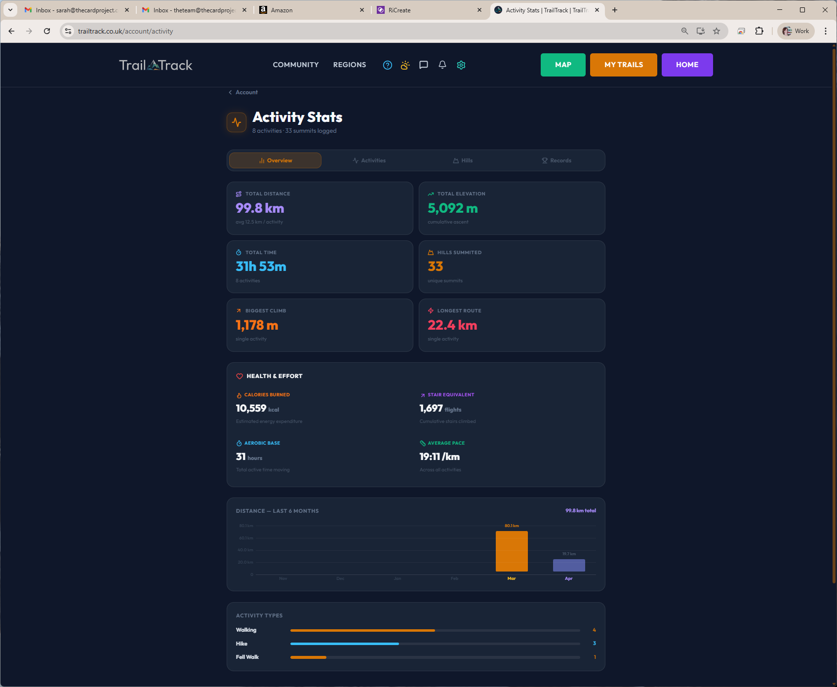
A Dashboard and the "Memory Book" Journal
When a user logs into TrailTrack, we want them to see their entire walking life in one place. We designed the account dashboard to pull in a lot of data: recent routes, total hill counts, follower activity, and personal records. To keep the site fast, we used parallel fetching, gathering all that information at the same time so the page arrives fully populated.
We also realized that many walkers like to keep a diary of their days out. Instead of building a separate "journal" feature, we made the route description field double as a personal journal. Any entry longer than a few words is treated as a journal entry.
But it’s more than just a log; it’s a digital memory book. Because the system automatically pulls in your geo-tagged photographs and attaches them to the route, you’re creating a permanent record of that day. You could look back in ten years and see not just the distance you walked, but the exact view you had at 2 PM, the faces of the people you were with, and the story of the day as you wrote it at the time. It turns a piece of software into a chronological diary of your life in the mountains.
Connecting with Like-Minded People
The community aspect of TrailTrack is about connecting with people who actually get why we do this. We built a space where users can follow like-minded walkers, swap stories about their latest adventures, and share their planned routes. We also added a "Group Activities" feature, where you can tag the friends you walked with so that the route appears on everyone’s feed automatically.
Our messaging system is built for more than just text. It supports photos, videos, and voice notes—which are great for when you’re on the move and your hands are too cold to type. You can even share a route directly into a conversation, making it easy to plan the next weekend’s outing. Whether it's discussing the best place for a post-walk pint or debating the most efficient way to link three different peaks, the community is the heart of what we are building.
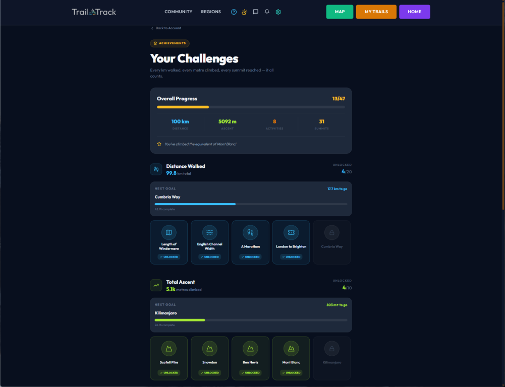
Tracking Progress: Personal Bests and Classifications
To keep the platform engaging, we’ve developed a deep tracking system that goes far beyond simple distance. We wanted to celebrate every aspect of a user's effort, especially when they manage to break their own records.
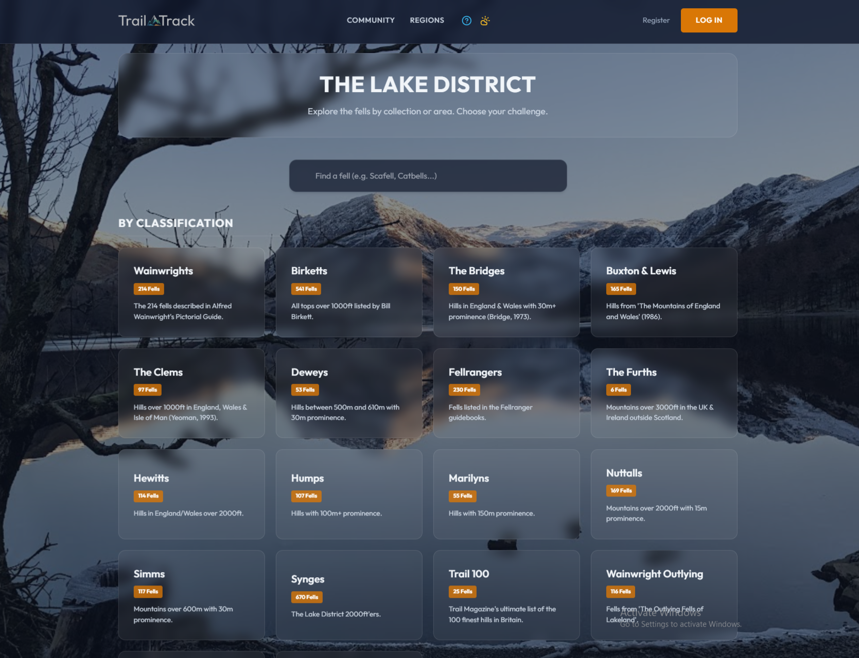
First, there are the "Classification Progress" cards. Whether you are working through the 214 Wainwrights or the 282 Munros, the system tracks exactly where you stand. We built a live database query that de-duplicates your climbs—counting each unique peak once toward your total while still tracking your "repeat" climbs separately. It gives you a clear, visual percentage of how close you are to finishing a list, with progress bars that update the second a new walk is processed.
Then there are the "Personal Bests." The software scans your entire history to highlight your standout achievements. This includes your longest route (by distance), your maximum ascent in a single activity, and your longest duration in the hills. We even calculate your fastest pace, but we built in a bit of intelligence there—the system only counts activities over 1km and 1 minute to filter out short test uploads or "accidental" recordings.
We also added "Milestone Challenges"—fun targets that put your effort into perspective. You might start by hitting a distance milestone equal to the length of Windermere, but eventually, you could be aiming for the "Edge of Space" milestone, which tracks your cumulative ascent up to 100,000 meters. Seeing these records update over months and years gives you a real sense of scale for the hard work you’ve put into the hills. It’s about those moments where you look at your screen and realize you’ve walked further or climbed higher than you ever have before.
Why Our Approach Works
Because we handle the software, design, and marketing as one team, TrailTrack is being built as a finished product rather than a collection of features. We didn't build a mapping tool and then try to figure out how to market it. We are building a platform that solves the actual problems we face as walkers.
We used a practical, code-first approach to handle the heavy lifting of data analysis, which allowed us to spend more time on the details that matter—like making sure the OS maps load quickly and that the privacy zones around a user's home are rock-solid. TrailTrack is a professional-grade tool built by people who actually use it.
Whether it’s a complex GPS parsing engine or a beautiful, responsive user interface, we have the skills to see a project through from the first line of code to the final marketing push. We aren't just developers; we are designers, marketers, and most importantly, users.
If you have a project that needs that same level of deep understanding and technical skill, we’d love to hear from you. We don’t just build software—we build solutions that we’d be proud to use ourselves.
Get in Touch!